The John Muir Trail is 211 miles long and the amount of time it takes really just depends on how many miles you are willing to hike and climb in a day. Many people set out on the John Muir Trail thinking that they want to finish the trail in X amount of days so they will hike 211/X number of miles a day. This method generally works. But there were areas that I wanted to specifically camp at and I knew I would want easy days after days with large ascents. So I went above and beyond in my planning to make the perfect schedule for me. For the most part, I stuck to the schedule and it worked out really well. There are some things that I would change and I will mention them later in this post.
Before you start planning, you need to first secure your permit, so you know what trailhead you are going to start at and when. My permit was from Cottonwood Lakes, starting June 28th. A little bit about permits, northbound permits are easier to secure early, since they are first come, first serve, and are released before the lotteries of the southbound permits. I secured my cottonwood lakes permit in January 2022, and continued to enter the weekly lotteries for southbound. After a couple of weeks of trying, I gave up and settled for my northbound cottonwood lakes start.
Once I settled on where and when I would start the JMT (and that I am really going to do it), I purchased the National Geographic and Tom Harrison Maps of the JMT. Why both? Because I liked seeing the elevation profiles on the NG maps but they ended at Mt. Whitney, whole the Tom Harrison Maps included all the way to Cottonwood Lakes. Both sets of maps have bear box locations, easy to read mileage markers, and reliable water locations. I needed the maps before planning because I wanted to camp my first couple of nights after a resupply near a bear box, in case I could not fit all my smelly items in my bear canister.
Once I had my maps, my start date, and my start location, I was ready to make a plan. From watching peoples YouTube videos about the JMT, I knew I wanted to camp at Crabtree Meadows, Palisades Lakes, VVR, Red’s meadow and thousand island lake. Also knowing my own limitations, I knew about 12 miles a day average would be decent for if there was less than 2,000 ft of elevation gain. If there was more elevation gain, maybe shorter mileage that day or the following day. Another factor some might want to consider is the altitude of where you are camping. If altitude sickness affects you, in general, you don’t want to camp more than 1,000 ft. higher than the previous night.
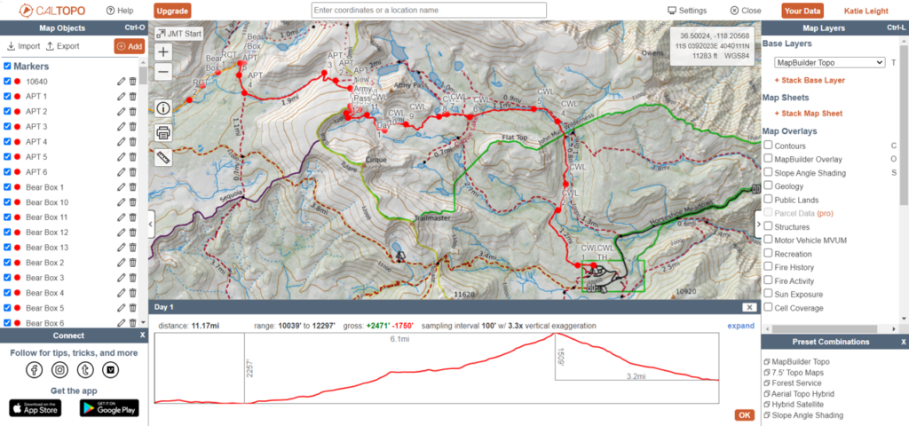
To make the plan, I used Caltopo. In Caltopo, you can import the JMT gps file of waypoints and use the existing trail system to make a route and look at the elevation gain, loss and the total mileage. You can save the file to your account, and export the gps file to save on your garmin device. All of this is with the free caltopo account.

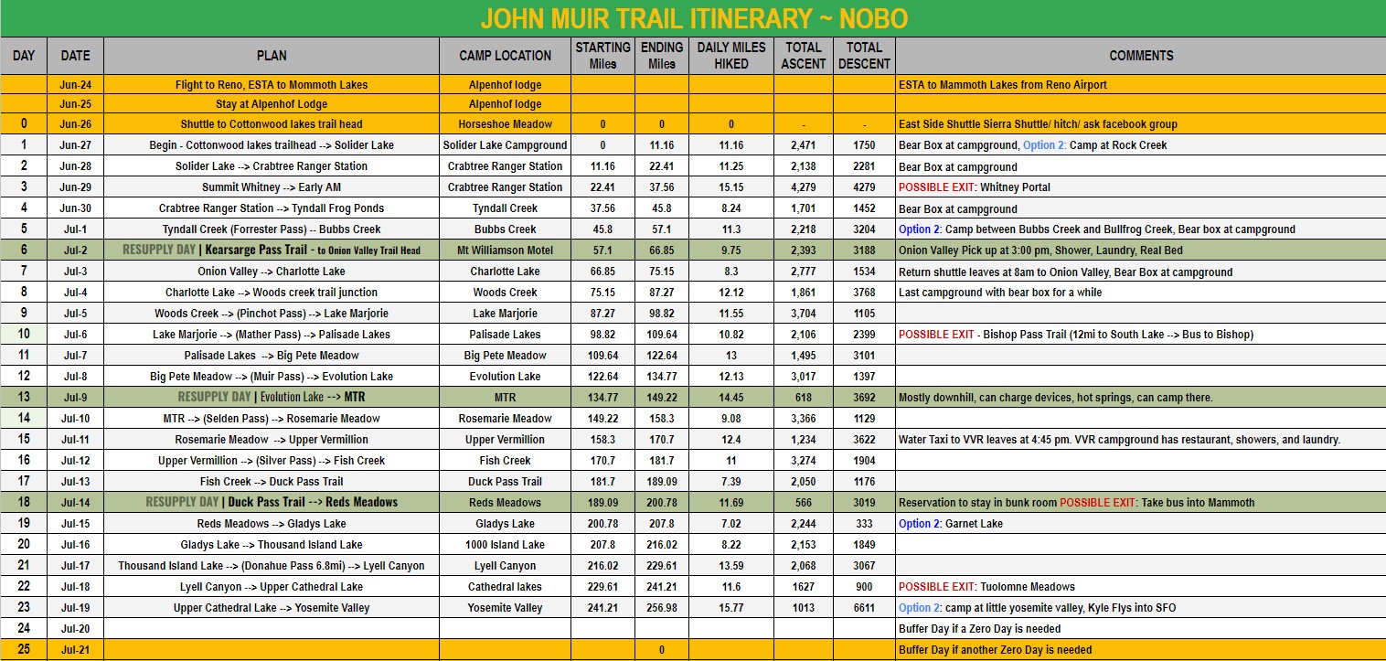
Once I figured out where I wanted to camp, I would save the start and ending location, mileage, ascent, and descent in a google sheet. I decided on Onion Valley (Mt. Williamson Motel), Muir Trail Ranch, and Red’s Meadow as my resupply options because I didn’t want to carry more than 7 days of food, and wanted to resupply as little as possible since I knew the shipping costs would add up. So I factored in these stops into my schedule as well. Once I had my plan, I wrote in on my NG and TH maps where I would be camping each night. The schedule I came up with and mostly stuck to is below.

For the most part, I stuck to the plan. There were 3 times where I camped about 1 mile before I thought I would. Twice was because I had heard it was more buggy where I had planned to camp so I stopped at a higher sight with less bugs. Once was because I didn’t think I would make it to MTR in time to repack my resupply before they collected the trash and closed up, so I camped at the campground right before MTR. Because I stuck to the schedule and I knew my husband could pick me up from Yosemite valley the morning of my 24th day, I camped at Little Yosemite Valley the night before and did the last 5 miles on day 24. Downloading the Far Out app and buying the John Muir Trail was worth it for quickly checking where known campsites are (there are a lot more in the app then on the physical maps). The Far Out app also has the most recent comments (when you last had signal and updated the app) that will have comments that will help you decide if you should stop or keep going.
Things I would change – There was no need to stay at Red’s Meadow. It looked really fun on some YouTube videos I saw, but after the last bus to mammoth left, it was quite and pretty much empty. I could have easily, resupplied and kept going. VVR gave me the community and fun that I thought Red’s would. Because I wanted to camp at VVR, Red’s and 1000 island lake, I had 2 days in between each and if I were to do this again, I would skip camping at Red’s and hike VVR to 1000 island lake in 3 days instead of 4.
TLDR:
Steps to plan your route:
- Get your permit.
- Decide on factors that will form your plan: how many miles you are willing to hike and how high your are willing to climb a day. Are there any places you really want to camp? Do you need bear boxes at your campgrounds? Do you want to camp at your resupply locations? Etc.
- Make an account with CalTopo.com and import JMT gps waypoint file.
- In CalTopo, create a route for each day, adjusting for mileage, ascent, descent, and campground elevation and locations.
- Save information in a google sheet.
- Mark the physical maps that you will bring with you for where you plan to camp.
- Add an extra day or two because you never know what might happen.
